Friday, June 12, 2015

Cliffs of Moher from the water

Cliffs of Moher

When we woke up in Doolin on June 4th it looked like it was going to be a nice day. It was sunny and the wind had finally died down. Kathie suggested that I do one of the boat trips to get pictures of the cliffs from the water. The trip was advertized as an hour long and was only €15 so she signed me up for the 5:15 excursion. 

Don't drive here.
When I showed up for to the pier and checked in the manager and I were watching the waves crash against the cliffs near the pier and he said "There is a lot of energy in those waves today."  This was the first sign that the trip was not going to be a nice smooth boat ride. 


Please sir will you please stand in my picture?
Nearly got my feet wet.
The ~50 foot boat we were going out on was late getting back from the previous tour, and when it did get back the people on the boat did not look like they were feeling that good. In addition even though the boat was tied to the pier the boat was being thrown about by the waves. The boat was moving 5 - 6 feet with every wave and the people getting off the boat needed time their leap off the boat onto to the pier with assistance from two of the crew members.  

After helping the people off the boat the manager informed us that we would not be returning to this port because it was too rough. We would land at another port and they would taxi us back to the Doolin pier. 

So I knew it was not going to be a smooth trip. 

When we got out of the harbour the waves were 4 - 5 meters but they were fairly well spaced.  I was glad that I have spent a fair amount of time on the ocean, the couple from Colorado who had never been on the ocean were not feeling very good though. 

I moved to the upper deck because the people that were not feeling well were lined up against the railing and I didn't want them in my pictures.  The problem was the movement on the top deck was much worse and taking pictures of the cliffs was a real challenge because the boat was moving so much I had to hang on with one hand while trying to hold the camera steady and level as I took pictures of the cliffs. 

I took a quite a few pictures and as we got further south the waves got up to 6 metres. 

Our hour long trip ended up being over 1.5 hours. And we laned at the beautiful small village of Liscannor, where a taxi was waiting for us. The ride back was very quiet as every one tried to recover. I sat up front with the taxi driver and one of the crew from the boat where I got to listen to the local gossip. 


Looking back toward Doolin.

Highest part of the cliffs

Nag's Head

South End


It seems that every village had their own castle.  This is one of two we could see from the bay where we docked the boat.


Neighbourhood Castle


Wednesday, June 3, 2015

Doolin and Surrounding Castles

Today we drove around the area to check out the Burren and look for castles.  The Burren is the local landscape that is much like Canadian Shield of "northern" Ontario.  Mainly rock with strips of grass and low shrubs.  Not much can grow here because there is very little soil.

This is what remains of a castle near the campground.  I got this one the other day but today I got it from the campground.

 On our way we stopped by a small town and I found this old church.  I took this shot from the outside looking in.


This church had arrow slits in it, so I am guessing the congregation were not pacifists. 


As we drive around Ireland it seems like everyone had a castle.  This one the old castle is to the right of the manor house that was built beside it.


This it the castle part and judging from the number of arrow slits I think this castle was attacked more than once.


This church is in even worse shape than the one above.


Poulnabrone tomb from about 5000 years ago.

http://irisharchaeology.ie/2013/06/poulnabrone-tomb-life-and-death-in-the-burren/


The Burren.  You can see that nothing grows here except low shrubs and grass.  In the distance you can see large outcropping of rock.  The tomb is also in the Burren and you can see what it looks like close-up.


Tuesday, June 2, 2015

Doolin and the Cliffs of Moher

Today we drove from Blarney to Doolin.  Doolin is right on the coast south of Galway.  We are only 7 kilometres from the Cliffs of Moher.  After lunch we went to the cliffs and spent some time there.  It is a huge tourist attraction with parking lots for cars and buses.  There were over 20 buses in the lot when we were there and we passed 3 more on the way back to the campground.

Here is the view from the lookout tower at the north end of the cliffs.


The weather changes quickly, a squall was just off the end but we did not get wet.  They have a visitor centre, gift shops and a couple of cafes.


After we got back I walked into the village of Doolin.  It was a treacherous walk down the road as it is very narrow with only enough room for two small cars to pass and it is lined by two rock walls so there is no where to go.

I got this picture in the village.  It is a thatch roofed store.


These are the remains of Doolin Castle.


Monday, June 1, 2015

Blarney Castle

Who would have thought that on June 1 my most valued possessions were my waterproof hiking shoes, waterproof FroggTogg jacket and my (now soaked) Tilly hat.  Today there was a wind warning and when it wasn't raining it was pouring.  I know now why Ireland is so green.

We spent the day at Blarney Castle.  Kathie and I kissed the Blarney Stone.  The stone is at the top level of the castle you see below.  Because the castle is in ruin, there are many areas that are exposed to the weather, so today they were very wet.  The climb up and down was narrow, we had to be very careful on steep smooth stone steps and some of the passages were only as wide as my shoulders.


The castle from a different angle.


The inside of the Watch Tower.  It is the small tower in front of the castle you can see in the first picture.  The holes you see are for the circular stair case  that went to the top of the tower.


One of the castle towers.


This was one of the waterfalls on the walks around the castle grounds.


The Druids apparently had a rock garden similar to Stonehenge in the area.


This is the Witch's Stone.  The right side looks like a witch's head.


This is from underneath one of the waterfalls.


Here is Kathie going down the Wishing Stairs.  You have to make a wish, go down backwards - with your eyes closed, thinking of nothing but your wish for it to come true.  The stairs are smooth rock and were very slippery in the rain.


Sunday, May 31, 2015

Moving South and East then West

Yesterday we drove from Roscrea to Enniscorthy.  Enniscorthy is where my grandmother grew up. Kathie had found a census form from around 1904 that was for my grandmother's family and they lived at 10 St John's Street.  On our way to the campsite we drove the Enniscorthy and found the street and #10.  It is not far from the Enniscorthy Castle.  The worst traffic we have come across so far was here.  It wasn't that there was that much traffic, it was just the roads are really narrow and traffic can't move that fast.

Here is #10 St John Street.


The street was very narrow and getting the motorhome by all of the cars was tricky.  #10 is the first door on the right.


All of the signs here are in Gaelic and English.


The campground here are all fairly similar.  Grass with gravel pitches were the campers are parked.  If it is a trailer the tow vehicle parks beside the camper on the grass.  The trailers here remind me of the trailers in the 1960's.  The tow vehicles are cars and the trailers are usually about 16 feet long.  Even at that, trying to get down the access roads with someone coming the other way must be interesting.


The weather last night was very wet and windy.  The drive today was OK, mostly dry but a couple of heavy rain squalls and windy.

Today we drove across the south of Ireland to Blarney.  Tomorrow we will tour the castle and Tuesday we will move north to the Cliff of Moher.

Saturday, May 30, 2015

Kathie's Family, Paul's Family

I am posting this late Saturday night. We have been having issues with the internet connection here. The campground said it had WiFi but you have to be standing right outside the office to get the best connection and it is pouring rain and very windy.

The last couple of days were spent around County Offaly at Castle Eglish and with a distant cousin of Kathie's.  We had a wonderful evening with Salters and his partner Michael in their home, which is a former church rectory.

Today we drove through Enniscorthy where my grandmother grew up. We stopped by St John's Street and I got some pictures that I will post tomorrow if we can get a decent internet connection.

We are in Ballagheen and tormorrow we are moving to Blarney and after that the Cliffs of Moher.

Thursday, May 28, 2015

Ancient Place, Newer Places

Our hearts and prayers go out to my brother, sister-in-law and the family as Margaret's mom passed away yesterday.

Yesterday we drove out to Newgrange.  It is a site similar to but older than StoneHenge.  The large mound you see was built 5,000 years ago.  Inside there is narrow passage ways that lead to a central room with 4 smaller areas off that room.  The passageway is aligned with the rising of the sun on the winter solstice and the inner chamber is lit by the sun for 17 minutes only on that day.  The requirement would be that is was not raining.  From what we have seen while we have been here the chamber was not lit on very many winter solstices.  There are a number of large stones that were quarried, moved by boat, brought up the hill and erected similar to Stonehenge.  Not bad for 3000 BC.


This is the carved rock in front of the entrance way to the passage.


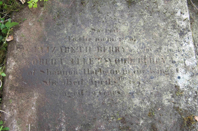
From North Beach, Rush we have moved to Roscrea.  This is the closest campground to the Eglish Castle which is the ancestral home of Kathie's family.  Before we left Kathie contacted the current owners (the Alexander's) and we were given permission to go onto the land and take pictures.  When we got here we got a tour by one of the brothers (Norman) who currently own the property.  He first took us to the grave yard where we spent some time cleaning off the old headstones and taking pictures so we can try to document who is buried there.  We had a great time as he was able to tell us about growing up the house and area.  He also helped us clean off the old tombstones so we get better pictures of them.

I am hoping when I get home I can enhance the pictures so that they are easier to read.


The headstones are in an area that is enclosed by the rock wall.  There are several other families buried in the grave yard but the Berry's are the only one with a rock wall surrounding the tombs.


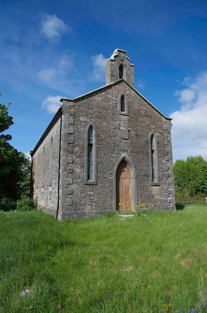
This is the old church on the property.


This is the old Berry manor house.  Part of what is left of castle wall is on the right side of the house. Norman and his brothers lived in the house until the 1990's.  The house is 4 levels including the basement.  The house had 32 rooms and had been built in 3 stages.  There was the original house, that was added onto the back, that was added onto the front and that was added onto the side.


This picture was taken from behind the white bales in the picture above.  This is what is left of the kitchen.  You can see the top a basement door underneath the green door, and there is another door just above the brown door.


On the north side of the house you can see more of what is left of the old castle.  Unfortunately, help is needed to identify what is former castle and what is rock wall.  On both sides of the farm equipment (the big white and blue thing) are part of the castle wall.  On the right side it is over grown with ivy and blackberries and on the left side it is behind the plough.  It looks like the wall was cut at some point to let farm equipment through.


This is the south side of the house with the castle wall on the left.  The windows were bricked up some time in the past when part of the house taxes were based on the number of windows in the house.


Front steps


The front of the house has been taken over by trees but you can see the that the roof has fallen in.


This is where Norman's dad blew out the wall in the house so he could park farm equipment.


Wednesday, May 27, 2015

Ireland - North Beach, Rush

Yesterday we picked up the motorhome / camper van and drove a short distance to a place north of Dublin on the coast.  The first part of the journey was on the motorway which is a freeway, but as we got closer to the campground the roads got very narrow and driving on the wrong side of the road is quite an experience.

We spent the afternoon hanging around the campsite, taking pictures and trying to get internet connections going.  We got things straighten out about 11:30 pm.

We met a couple from Germany who had an Entlebucher Mountain Dog and we spent some time talking with them.

Here are some pictures from the campsite.  The first 4 are the view from right in front of the motorhome, looking west toward England.  If you have panorama software you can piece them together to get the complete picture.  This reminds me of the place my family used to stay at Qualicum Beach when I was growing up.


This is our motorhome.  You can see the Entlebucher Mountain Dog by the other camper.


Here are the campers lined up on the bank above the beach.  We are the third camper from the left.


We got some sad news late yesterday, our dog Kody passed away.  Thanks to our friend Don who has been looking after him while we have been away.